


LiDAR, or Light Detection and Ranging, is new technology that is improving many activities.
“It is a significant generational change,” said AMC cartographer Larry Garland of Jackson recently.
kAmxE :D 2 C6>@E6 D6?D:?8 >6E9@5 E92E FD6D =:89E :? E96 7@C> @7 2 AF=D65 =2D6C E@ >62DFC6 5:DE2?46D] p? 2:CA=2?6 H:E9 E9:D 56G:46 7=:6D @G6C 2? 2C62 2?5 244FC2E6=J >2AD E96 =2?5D42A6] tG6CJ D>2== G2C:2E:@? :? E96 E@A@8C2A9J 364@>6D 6G:56?E] %9:D 92D 364@>6 2 3@@? ?@E @?=J 7@C >2A >2<6CD[ 3FE 7@C 86@=@8:DED 2?5 2C4926@=@8:DED]k^Am
kAm(92E 92D :E 5@?6 7@C 9:<:?8 2?5 9:<:?8 >2ADn xE :D 2? F?56CDE2E6>6?E E92E {:sp# :D >@C6 244FC2E6 >62DFC:?8 6=6G2E:@? E92? :? AC6G:@FD >2A >2<:?8] xE :D 244FC2E6 E@ =6DD E92? 2 7@@E]k^Am
kAmv2C=2?5 92D >256 >2AD 7@C E96 p|r D:?46 `hhe] w6 2=D@ 92D >256 >2AD 7@C >2?J @E96C ?@CE962DE @FE5@@C 2?5 4@?D6CG2E:@? @C82?:K2E:@?D] w6 :D @7E6? @FE @? E96 EC2:= H:E9 2? 25G2?465 v!$ 324<A24< 4@==64E:?8 EC2:= :?7@C>2E:@?[ E96? C6EFC?D E@ 9:D @77:46 2E 9@>6 :? y24<D@? 2?5 5@H?=@25D :E :?E@ v6@8C2A9:4 x?7@C>2E:@? D@7EH2C6]k^Am
kAmw6 D2:5 E92E E96 6IA6?D:G6 AC@46DD @7 >2AA:?8 DE2E6D H:E9 {:sp# :D H6== F?56CH2J] }6H w2>AD9:C6 H2D 7:?:D965 :? =2E6 a_`g[ 2?5 |2:?6 :D F?56CH2J] “|@DE {:sp# :D 4@?EC24E65 E9C@F89 E96 &]$] v6@=@8:42= $FCG6J[ E@ E96:C DA64:7:42E:@?D[” 96 D2:5] “%96 2:CA=2?6 7=:6D 2 DA64:7:4 A2EE6C? FD:?8 8C@F?5 4@?EC@= A@:?ED]”k^Am
kAmx 2D<65 9:> :7 p|r >2AD 2C6 FA52E65]k^Am
kAm“tG6CJ d J62CD 2 ?6H p|r (9:E6 |@F?E2:? vF:56 4@>6D @FE[” 96 D2:5] “%96 b_E9 65:E:@? W>2ADX E92E 42>6 @FE :? a_`f H6C6 >256 367@C6 E96 2AA=:42E:@? @7 {:sp#] %96 b`DE 65:E:@? 4@>6D @FE E9:D 72== H:E9 ?6H >2AD 2?5 D@>6 ?6H 6=6G2E:@?D]”k^Am
kAmv6@8C2A9:4 $FCG6J 52E2 7C@> {:sp# >2AA:?8 :D AF3=:4 :?7@C>2E:@?] (96? v2C=2?5 C6EC:6G65 :E 96 7@F?5 D@>6 :?E6C6DE:?8 6=6G2E:@? 492?86D E92E 2C6 @7 :?E6C6DE E@ 9:<6CD[ 6DA64:2==J E9@D6 5@:?8 E96 cg c[___ 7@@E6CD] s6DA:E6 E96D6 DFCAC:D6D[ E96 p|r c[___ u@@E6C r@>>:EE66 92D 564:565 E@ <66A E96 EC25:E:@?2= =:DE]k^Am
kAm!C6G:@FD=J |@F?E %64F>D69 H2D c[__b 766E] %96 ?6H 6=6G2E:@? :D b[hhd 766E] |@F?E p52>D Wd[fhh 766EX :D ab 766E 9:896C 2E d[gaa 766E] $@FE9 w2?4@4< Wc[b`h 766EX :D ea 766E =@H6C[ 2E c[adf 766E] p=D@ {:sp# :?5:42E6D E96C6 :D ?@E 2 a__\7@@E C:D6 E@ :ED DF>>:E 7C@> E96 4@= 36EH66? }@CE9 2?5 $@FE9 w2?4@4<[ ?@C>2==J C6BF:C65 7@C $@FE9 w2?4@4< E@ 36 @? E96 c[___ 7@@E6C =:DE] *6E E96 p|r c[___ u@@E6C r@>>:EE66 92D <6AE :E @? E96 =:DE] |@F?E vFJ@E H2D ?@E @? E96 =:DE 3642FD6 E96C6 H2D ?@E 2 a__ C:D6 7C@> E96 D255=6 36EH66? |@F?E q@?5 2?5 |@F?E vFJ@E] {:sp# D2JD :E 5@6D 92G6 E92E a__ 7@@E C:D6]k^Am
kAm%96 EC25:E:@?2= p|r c[___ 7@@E6C =:DE H:== C6>2:?] ~E96C EC2:= @C82?:K2E:@?’D DF49 2D E96 %C2:=HC:89ED >2J C6\6G2=F2E6]k^Am
kAmp?@E96C 72D4:?2E:?8 FD6 @7 {:sp# :D 86@=@8J] #646?E=J 86@=@8:DE qC:2? u@H=6C H2D :? E96 7:6=5 ?62C (9:E67246 x?E6CG2=6 :? }@CE9 $2?5H:49[ H@C<:?8 @? 2 }6H w2>AD9:C6 v6@=@8:42= $FCG6J >2A]k^Am
kAm%96 (:D4@?D:? :46 D966E H2D :? 7F== C6EC62E `c[___ J62CD 28@] *6E u@H=6C 7@F?5 6G:56?46 @7 5CF>=:?D 2?5 >@C2:?6D E92E :?5:42E65 25G2?46>6?E @7 :46 5FC:?8 2 C6?6H65 A6C:@5 @7 4@=5 5FC:?8 E96 C6EC62E] %9:D 4@=5 A6C:@5 92D 366? H6== 5@4F>6?E65] qFE E96 :?E6C6DE:?8 E9:?8 H2D E92E[ C2E96C E92? 25G2?4:?8 324< D@FE9[ E96 25G2?46>6?E H2D E@ E96 ?@CE962DE]k^Am
kAmw:D 4@==628F6 (@@5J %9@>AD@? H2D H@C<:?8 @? 2 }wv$ >2A 2D H6== :? E96 $BF2> {2<6 2C62] %9@>AD@? 7@F?5 DEC:2E:@?D @? C@4<D @? {@?8 xD=2?5 :? $BF2> {2<6 E92E H6C6 2=D@ 962565 ?@CE962DE]k^Am
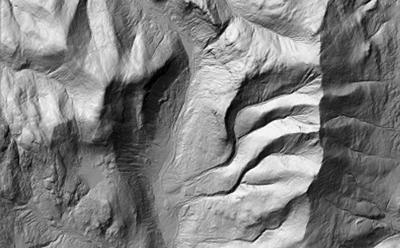
kAm%96 FD6 @7 {:sp#[ H9:49 D9@HD 6G6CJ C:AA=6 :? E96 =2?5D42A6[ H2D FD67F= :? 7:?5:?8 2? 6IA=2?2E:@? 7@C E96 ?@CE962DE 7=@H] x46 3682? 25G2?4:?8 D@FE9 5FC:?8 E9:D D9@CE 4@=5 A6C:@5[ H2D 567=64E65 3J E96 ~DD:A66 #2?86 2?5 EFC?65 ?@CE962DE[ C:D:?8 A2CE H2J FA E96 $2?5H:49 C2?86[ =62G:?8 5CF>=:?D 2?5 >@C2:?6D]k^Am
kAm%9:D 92AA6?65 :? @?6 D>2== =@42E:@? 5FC:?8 E96 C6EC62E @7 E96 8=24:6C] *6E :E 56>@?DEC2E6D 9@H E96 DEF5J @7 DFC7246 86@=@8J 92D E2<6? 2 =62A 7@CH2C5 H:E9 E96 FD6 @7 {:sp#]k^Am
kAmpD 7@C 2C4926@=@8J[ E96 >2AA:?8 @7 DE@?6 H2==D :? }6H t?8=2?5 92D ?6H =:76[ 2D E96J 2C6 62D:=J G:D:3=6 H:E9 {:sp#] r964< @FE E96 $E@?6 (2== |2AA6C 3J }w vC2?:E 2E k2 9C67lQ9EEAi^^8C2?:E]F?9]65F^C6D@FC46=:3C2CJ^DA64:2=E@A:4D^DE@?6H2==DQm8C2?:E]F?9]65F^C6D@FC46=:3C2CJ^DA64:2=E@A:4D^DE@?6H2==Dk^2m] *@F 42? A2CE:4:A2E6[ 255:?8 J@FC <?@H=6586 @7 DE@?6 H2== =@42E:@?D]k^Am
kAmpD 7@C 2C@F?5 E96 H@C=5[ :? r6?EC2= 2?5 $@FE9 p>6C:42[ E96J 2C6 =:E6C2==J 7:?5:?8 F?<?@H? 4:E:6D E92E H6C6 9:556? 3J E96 ;F?8=6] p?@E96C 7FEFC6 FD6 @7 E9:D E649?@=@8J :D 5C:G6C\=6DD 42CD[ H96C6 :E :D FD65 E@ 2G@:5 @3;64ED]k^Am
kAmu@C E9@D6 H9@ 92G6?’E D66? 2 {:sp# >2A[ E96 r9@4@CF2 {2<6 r@?D6G2?4J 92D 2 r9@4@CF2 |2A pAA W49@4@CF2=2<6]@C8^49@4@CF2\>2A\2AAX E92E J@F 42? 5@H?=@25 @? :~$ >@3:=6 56G:D6D]k^Am
kAm%@ 2 86@=@8:DE[ E96 >2A C6G62=D E96 8=24:2= 9:DE@CJ @7 E96 32D:? :? C6>2C<23=6 56E2:=[ 2?5 E@ E96 =2J>2?[ E96 62CE9 36?62E9 E96 EC66D :? 2== :ED 4@>A=6I:EJ] %9:D 2AA 9@=5D 2 H62=E9 @7 :?7@C>2E:@? 23@FE EC2:=D[ 86@=@8J[ 6=6G2E:@? 82:? 2?5 >@C6 3J E2AA:?8 @? 2 =@42E:@?]k^Am
kAmxE H2D 56G6=@A65 3J #:4< p==>6?5:?86C[ 2 AC@76DD@C 6>6C:EFD @7 62CE9 D4:6?46D 2E r@C?6==] %@52J 96 =:G6D :? %2>H@CE9 2?5 :D @? E96 3@2C5 @7 E96 r9@4@CF2 {2<6 r@?D6CG2?4J]k^Am


(0) comments
Welcome to the discussion.
Log In
Keep it Clean. Please avoid obscene, vulgar, lewd, racist or sexually-oriented language.
PLEASE TURN OFF YOUR CAPS LOCK.
Don't Threaten. Threats of harming another person will not be tolerated.
Be Truthful. Don't knowingly lie about anyone or anything.
Be Nice. No racism, sexism or any sort of -ism that is degrading to another person.
Be Proactive. Use the 'Report' link on each comment to let us know of abusive posts.
Share with Us. We'd love to hear eyewitness accounts, the history behind an article.