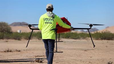
(BPT) - Every construction project, property transaction, infrastructure upgrade and urban planning project begins with one essential requirement: accurate data about the land. That's where land surveys usually come into play. Think of it like a map with legal power — it turns unclear lines on paper into precise measurements on the ground. Surveyors measure and map terrain features, determine property boundaries, calculate elevations and define spatial relationships that guide critical decisions. Without a land survey, decisions are based on assumptions. With a land survey, you have clarity and legal protection.
Yet, despite its essential role in modern development projects, land surveying has traditionally remained a "low-tech" industry dominated by a tripod-mounted measurement tool popularized in the 1980s called a "total station." As a result, land surveys can often be time-consuming, hazardous and limited in the type and amount of data they provide. On larger sites or hilly terrains, surveyors usually require multiple days or even weeks to complete a job, and teams frequently operate in risky conditions or difficult-to-access areas: near traffic, on active construction zones and on rooftops. This increases the risk of injury for surveyors while also limiting the efficiency and precision of data collection.
Keep it Clean. Please avoid obscene, vulgar, lewd,
racist or sexually-oriented language. PLEASE TURN OFF YOUR CAPS LOCK. Don't Threaten. Threats of harming another
person will not be tolerated. Be Truthful. Don't knowingly lie about anyone
or anything. Be Nice. No racism, sexism or any sort of -ism
that is degrading to another person. Be Proactive. Use the 'Report' link on
each comment to let us know of abusive posts. Share with Us. We'd love to hear eyewitness
accounts, the history behind an article.


(0) comments
Welcome to the discussion.
Log In
Keep it Clean. Please avoid obscene, vulgar, lewd, racist or sexually-oriented language.
PLEASE TURN OFF YOUR CAPS LOCK.
Don't Threaten. Threats of harming another person will not be tolerated.
Be Truthful. Don't knowingly lie about anyone or anything.
Be Nice. No racism, sexism or any sort of -ism that is degrading to another person.
Be Proactive. Use the 'Report' link on each comment to let us know of abusive posts.
Share with Us. We'd love to hear eyewitness accounts, the history behind an article.