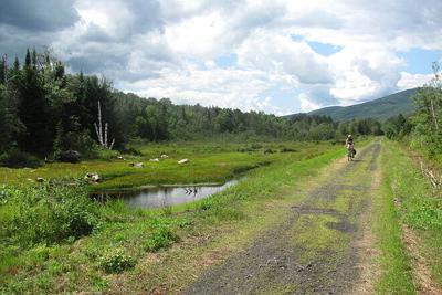
View from the Presidential Rail Trail which runs from Gorham to Whitefield. The state is updating its plan for the rail-trail system in New Hampshire. (COURTESY PHOTO)
View from the Presidential Rail Trail which runs from Gorham to Whitefield. The state is updating its plan for the rail-trail system in New Hampshire. (COURTESY PHOTO)
GORHAM — The N.H. Department of Transportation is updating its 2005 State Rail Trail Plan and is holding a virtual public meeting Thursday, Aug. 18 to gather public comments.
The New Hampshire Rail Trail system has more than 360 miles of recreational trails including two sections in Coos County. Running from Gorham to Cherry Pond in Whitefield is the 18-mile Presidential Rail Trail which goes through the Silvio O. Conte National Fish and Wildlife Refuge and provides great views of the Presidential Mountain range. The 7.5-mile Upper Coos Rail Trail between Colebrook and Beecher Falls, Vt., follows along the Connecticut River.
Keep it Clean. Please avoid obscene, vulgar, lewd,
racist or sexually-oriented language. PLEASE TURN OFF YOUR CAPS LOCK. Don't Threaten. Threats of harming another
person will not be tolerated. Be Truthful. Don't knowingly lie about anyone
or anything. Be Nice. No racism, sexism or any sort of -ism
that is degrading to another person. Be Proactive. Use the 'Report' link on
each comment to let us know of abusive posts. Share with Us. We'd love to hear eyewitness
accounts, the history behind an article.


(0) comments
Welcome to the discussion.
Log In
Keep it Clean. Please avoid obscene, vulgar, lewd, racist or sexually-oriented language.
PLEASE TURN OFF YOUR CAPS LOCK.
Don't Threaten. Threats of harming another person will not be tolerated.
Be Truthful. Don't knowingly lie about anyone or anything.
Be Nice. No racism, sexism or any sort of -ism that is degrading to another person.
Be Proactive. Use the 'Report' link on each comment to let us know of abusive posts.
Share with Us. We'd love to hear eyewitness accounts, the history behind an article.